


Chancellor Voting District, Spotsylvania County, Virginia
About
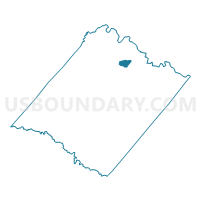
Outline

Summary
| Unique Area Identifier | 682570 |
| Name | Chancellor Voting District |
| County | Spotsylvania County |
| State | Virginia |
| Area (square miles) | 1.68 |
| Land Area (square miles) | 1.68 |
| Water Area (square miles) | 0.01 |
| % of Land Area | 99.67 |
| % of Water Area | 0.33 |
| Latitude of the Internal Point | 38.28070200 |
| Longtitude of the Internal Point | -77.57636450 |
Maps


Graphs
Select a template below for downloading or customizing gragh for Chancellor Voting District, Spotsylvania County, Virginia


Neighbors
Neighoring Voting District (by Name) Neighboring Voting District on the Map
- Ni River Voting District, Spotsylvania County, VA
- Piedmont Voting District, Spotsylvania County, VA
- Smith Station Voting District, Spotsylvania County, VA
Top 10 Neighboring County Subdivision (by Population) Neighboring County Subdivision on the Map
- Salem district, Spotsylvania County, VA (19,100)
- Chancellor district, Spotsylvania County, VA (16,699)
Top 10 Neighboring Unified School District (by Population) Neighboring Unified School District on the Map
Top 10 Neighboring State Legislative District Lower Chamber (by Population) Neighboring State Legislative District Lower Chamber on the Map
Top 10 Neighboring State Legislative District Upper Chamber (by Population) Neighboring State Legislative District Upper Chamber on the Map
Top 10 Neighboring 111th Congressional District (by Population) Neighboring 111th Congressional District on the Map
Top 10 Neighboring Census Tract (by Population) Neighboring Census Tract on the Map
- Census Tract 201.14, Spotsylvania County, VA (5,770)
- Census Tract 201.04, Spotsylvania County, VA (4,589)
- Census Tract 201.13, Spotsylvania County, VA (4,341)
- Census Tract 201.10, Spotsylvania County, VA (3,721)
- Census Tract 201.12, Spotsylvania County, VA (2,774)
- Census Tract 201.11, Spotsylvania County, VA (2,380)